
January 15, 2026
Georeferencing technologies: Gaudentius the App created by Ulixe for art and territory
September 15, 2023
Discover how geo-referencing enriches the cultural experience, with Ulixe's Gaudentius App we geo-referenced the land and art!
Geo-referencing technologies , a term at first glance complicated that actually indicates a very simple concept: the set of technologies for locating an object or event on the Earth's surface.
Today we will dive into this fascinating world that combines territory and technology!
In this article, I tell you how this technology has taken on a fundamental role in our daily lives. Also, together with a special guest: Francesco Scrufari, Co-Founder and Administrator of Ulixe Group, I tell you how Ulixe has employed this technology in a project that combines Art, Territory and Technology: the Gaudentius App.
Index
- Georeferencing technologies: locating in Our Reality.
- What is a GIS? The basis of georeferencing technologies
- A Case for Success: The Gaudentius App by Ulixe
Georeferencing Technologies: Locating in Our Reality.
The ability to share one's location or place an activity, artifact, or event in the world has become not only common, but also indispensable.
But what really is location? The gps location, after all, is "only" the qualifying component of geographic information.
Whether it is geographic coordinates, an address, or the distance along a major road, geographic location provides us with a unique way to locate and identify a point on a map.
Enrichment of the territory thanks to geodata
But there is something even more fascinating. Adding location to the set of information describing a place, architecture, event or whatever in real space means enriching it with geographic metadata that allows physical objects to be highlighted on a virtual map and interacted with. In this way, the overall information can be exploited transversally, in different applications and in a variety of subject areas.
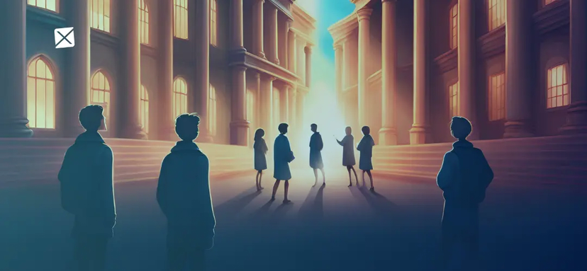
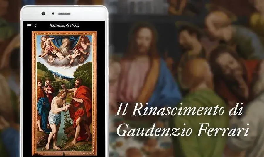
From environmental science to more playful purposes such as visiting a traveling art exhibition. Thanks to georeferencing technologies, it is possible to use an application on your smartphone that guides you along the exhibition route and provides information about it. This is the case with the application developed by Ulixe group for the exhibition 'The Renaissance of Gaudenzio Ferrari,' which in 2018, involves three cities in Piedmont, Varallo Sesia, Vercelli, and Novara.
What is a GIS? The basis of georeferencing technologies
Whenever we use a navigator or look for a place of interest within a virtual map we are taking advantage of a GIS system: Geographic Information System.
A GIS system is a complex of hardware and software that enables the management, analysis, and visualization of geographic data.
What's Behind GIS: Satellite Data and GPS
Geographic data used in a GIS system may include satellite photographs and GPS positioning information. These are essential for creating detailed and accurate georeferenced information.
Satellite photographs provide a detailed view of the earth's surface, enabling the identification and representation of geographical objects and features.
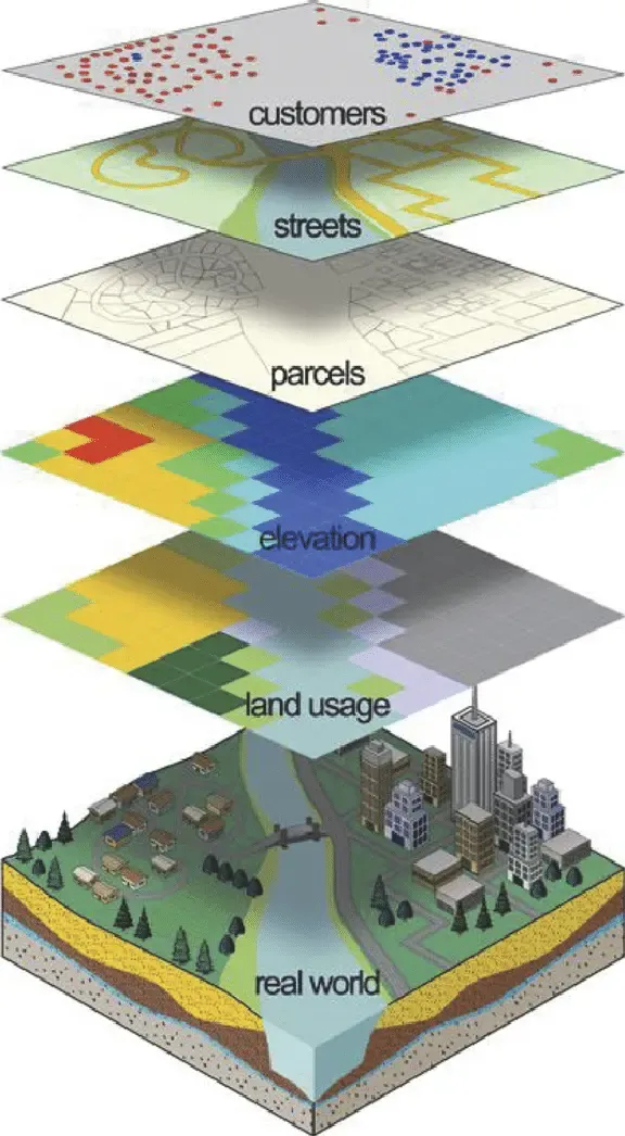
GIS layered model.
Source: ResearchGate
GPS localization, on the other hand, makes it possible to accurately determine the location of an object or event on the earth's surface using geographic coordinates.
In other words, a GIS system exploits satellite photographs and GPS positioning to create and manage georeferenced data, which in turn are used to provide accurate information and to support activities such as navigation and visualization of virtual interactive maps.
Georeferenced Databases: Structure and Software for Geographic Information
Georeferenced databases are fed by this set of data needed to build a geographic information system.
Georeferenced databases can be based on different software depending on the use and type of end user. They can handle maps in two or three dimensions on which various layers of information can be superimposed, such as sites of interest, roads, but also sector studies and analyses useful for research: through the integration of tele-detected data with cartographic, statistical, environmental data, etc., these platforms allow computerization and subsequent data querying.
One example of geospatial databases is PostGIS, which offers advanced capabilities for managing and analyzing geographic data within PostgreSQL. With PostGIS, you can create, query and analyze geographic objects such as points, lines and polygons.
For unstructured geographic data, however, NoSQL databases such as MongoDB may be more useful. MongoDB allows geographic data to be stored as JSON documents and supports indexing and spatial query for efficient data searching.
A Case for Success: The Gaudentius Appby Ulixe
Works of art, cultural events, food and wine, sports: everything in an area can be told through georeferenced content.
The Renaissance of Gaudenzio Ferrari
When you combine this system with Augmented Reality, you create an opportunity to create interactive and immersive experiences.
With these premises that, in the spring of 2018, Ulixe developed and released "Gaudenzio": the official app of the traveling exhibition "The Renaissance of Gaudenzio Ferrari". The app uses georeferencing to guide visitors along the exhibition route, providing detailed information about the artist's works of art and offering an engaging and interactive experience.
Together with Francesco Scrufari, CEO of the Ulixe Group, we examine how Ulixe integrated georeferencing technologies into the application and the different stages of the development process: from engagement to project decommissioning.
Gaudentius: Interview with Francesco Scrufari, Co-Founder of Ulixe Group
Gaudentius, Logo App
How did it come to propose an App based on georeferencing technologies? Ulixe has been collaborating with the Polytechnic and the University of Turin for years. During one of the regular meetings, the Department of Design of Arts presented the app project, in the making, regarding the traveling exhibition on the works of Gaudenzio Ferrari.
Faced with this challenge, Ulixe decided to employ its expertise in mobile technologies, and the idea of creating an app based on georeferencing technology was born. This choice stemmed from the desire to offer an interactive and engaging experience for visitors, guiding them through the places that housed Gaudenzio Ferrari's works, providing information about the works in real time.
The Importance of Geolocation in the Gaudentius App.
Geolocation technology played a critically important role in the application because Gaudenzio Ferrari's works were located in different locations. Theoption of using image recognition with georeferenced data immediately proved logical and effective.
The use of geolocation allowed users to be informed in real time when they were in the vicinity of one of these works via geographic Push notifications from "Gaudentius."
Moreover, thanks to Augmented Reality technology, visitors could explore the exhibition locations through their phone's camera, allowing the system to recognize the artist's works and provide detailed information through text pop-ups, captions, and even audio guides!
Finally, the geolocation technology employed was essential, as the application could create real interactive tours along the various "Ferrari places," providing an immersive experience and allowing visitors to explore the area in a unique way, guided by the magic of art and the convenience of technology.
Who was the working group that designed and implemented the platform composed of?
The work involved about twenty people, including some PhD students from the Department of Design, who were responsible for creating the navigation scheme and taking care of the aesthetics. Torino Musei, the client, provided ii content and information about the works, as well as publicizing the application. Ulixe, on the other hand, provided its mobile development unit (The Lab Torino), with its expertise in the field, to develop the application with an efficient and enjoyable user experience in relation to the potential user of the application.
Were studies or the hiring of new ad hoc staff specializing in georeferencing technologies needed to fill the missing skills?
The mobile unit's tasks include researching and developing new technological innovations, identifying the most interesting ones, and figuring out whether and how to integrate them, net of their usefulness and usability by the target audience.Among the various technologieswe used to develop the application and integrated into the Georeferential Data team's skill set.
Getting more technical: at the Back-End and data level, how is information managed and interpreted in relation to the territory?
Ulixe developed the back-end on AWSapartfrom the content that the department and speakers had already provided complete with the physical object location information. Metadata related to the works were entered into the DynamoDB database.
Subsequently, through the location information obtained in real time from the device used, thanks to theMaps SDK, a map display of the points of interest previously defined in the database was obtained; in this way, navigation took place directly in the app, which provided a preview of the places/works as well as directions to continue on the exhibition route.
Obviously, we have given the user the ability to "virtually browse" places and consult routes already from home, thus being able to choose their itinerary in advance based on their time or commute or themes.
What critical issues have been faced in implementing these mobile technologies on the ground?
The main difficulty was due to the fact that the works were located in various locations and some territories were not always effectively covered by the mobile network; in particular, if the artifacts were located inside ancient buildings, this could have created problems with data fruition or slowdowns that could have affected the use of "Gaudentius." In order to cope with this situation, when the app was opened, a pre-download of all locations was done, and in the vicinity of those locations, information about what was present in that area was cached(it should be noted that, at that time, regulations on background data usage and location were different from the current ones, ed.).
Tell us some trivia, some anecdotes from the project/development phase?
When different components of the working group present different needs and solutions, sometimes a kind of impasse can be reached. In these cases, one must not lose sight of the ultimate goal: to give the user of the platform the best possible experience based on the purposes of the software and the content provided by the client; therefore, effective relationship management is essential to optimize the platform not in the best way. At the technical level, it is necessary to take into account the target of the user who is going to use the application, concretely, and to build interface and navigation model accordingly; not only that: different users have different devices of different brands, very important, therefore, to make it functional regardless of the medium with which the App will be used.
What feedback did the app get from end users? What were the customer's reactions?
They liked the app very much and the reviews on the stores were very positive, rewarding the user experience. Turin Museums and the Polytechnic have appreciated the result and, as a result, we can talk about it as a successful product.
When the exhibition ended, the app was decommissioned: what does it feel like when one's own creation is no longer used?
Even though you knew from the beginning that the application would have a limited period of use, some regret is felt, especially if you are aware of how much energy and time has been spent to make it happen. Logically, it is all proportionate to how involved you are within the process: it is undeniable that sometimes you are so involved and have spent so much that you feel a piece missing...it is like saying goodbye to a friend you don't know if you will ever see again! However, when you know that you have accomplished something successful, you know that you will always carry it with you as a positive experience.
Thus, the experience of "Gaudentius" has enriched the Ulixe warehouse with new elements of mobile georeferencing: based on what was gained during this project, what has been or can be used in different contexts?
The system of the application, though decommissioned, is suitable for any kind of traveling exhibition or display; of course, to date, technological evolution has provided various tools that could make such a platform even faster and more usable. More recently, georeferencing technologies were used in a collaboration with the Museum of Cinema in Turin in an exhibition that included several video setups in various locations along the exhibition route: to enhance the sound experience, an App was developed that, thanks to the user's localization and synchronization with the videos in the exhibition, allowed the user to hear the audio through their cell phone.
What about today? Any other projects in the pipeline using the same technologies?
In recent years, various applications based on geolocation and georeferencing technologies have been released by the company. These technologies are now part of the experience of almost every mobile app starting, for example, with the localization of the user when logging in to ensure greater security: recognizing an attempt to log in from a location other than the usual one, the password and two-factor authentication are requested again. This is just one example to show how essential localization has become.
Conclusions
Geo-referencing technology has changed the way we live and interact with the world around us. Thanks to geo-referencing, we can discover, explore and learn about places and works of art in an engaging and innovative way. The Gaudentius App has been a successful example of how geo-referencing can enrich our cultural and tourism experience, opening up new possibilities for the future.

